GeoTag Release – October 2025
October release notes for the GeoTag asset tracking platform, with improved visibility, precision & usability.


Ashley
GeoTag Release Notes – October 2025
This update improves clarity and trust in your GeoTag tracker data, addressing several areas that previously caused user misinterpretation or confusion.
1. Improved Tracker Status Visibility
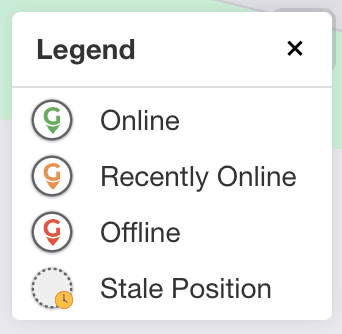
Scenario: Trackers sometimes appeared “Online” even when their map position was out of date. This could mislead users who assume this means the position is recent and current.
Why: The app always shows the last known position, while “Online” meant the tracker was communicating – not necessarily moving or GPS-connected.
What’s changed:
Positions older than 1 hour now show a “stale” icon (dotted circle with a clock) to remind users to check the timestamp.
A new “Recently Online” status (orange) indicates trackers last seen 20–60 minutes ago, helping identify when a device may have gone out of range or run out of power.
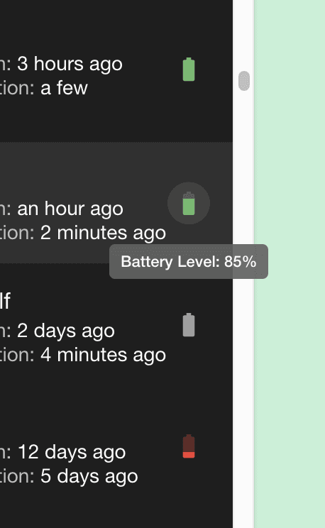
2. More Granular Battery Status & Stale Battery Readings
Battery readings are now displayed with greater precision and context:
Battery icons now update in 10% increments (previously only 4 steps).
Low and stale readings now display in red, indicating a depleted battery.
Stale but not low readings now appear grey, signalling that the data may be outdated.
Only recent but not low readings show green, indicating they can be relied on
3. “Last New Position” & “Last Communication” Indicators

To help you quickly understand what’s happening with your tracker:
Last New Position: When the tracker last sent new GPS coordinates.
Last Communication: When the tracker last connected to the server.
The GeoTag icon to the left now shows Green (online), Orange (recently online), or Red (offline)
These distinctions makes it clear if the device is active but stationary, whether there could be a GPS reception issue, or whether the device is offline at a glance.
4. No More Default (0,0) Position
New trackers with no location history will no longer display at (0°, 0°) (off the coast of Africa).
Instead, the platform will show “Last Position: —”, providing a clearer onboarding experience and improving trust.
5. Reduced Information Overload
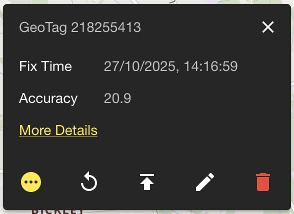
The Position Card -> More Details panel has been simplified.
Unnecessary technical fields have been removed to help users focus on the most relevant information without distraction.
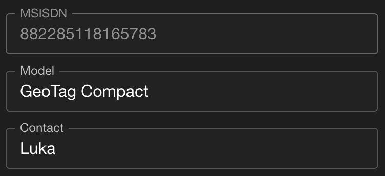
6. Prevented Accidental Editing of Critical Fields
Fields such as Identifier (IMEI) and MSISDN are now locked to prevent accidental edits that could disrupt device communication.
7. Bug Fixes
Fixed an issue where GeoTag icons would sometimes not render within a circle on Safari and iOS browsers, affecting iPhone users.
—-
By improving visibility, precision, and usability, the GeoTag platform now makes it even easier to understand what your GeoTag trackers are doing, and why.